Bainbridge: Bainbridge Island, just a relatively short ferry ride away from Seattle. Not as pastoral as it once was, but still quite a switch from downtown Seattle's steel and concrete labyrinths for those who want to have their cake and eat it too.
The Banana Belt: The area around Sequim (pronounced as "squim") which is in the rain shadow of the Olympic Mountains, resulting in a paucity of rainfall (less than 10 inches a year, I believe), a feature which has attracted a number of Hollywood stars in the past (John Wayne having been probably the most prominent--they even named a marina after him) as well as a gaggle of retirees to the area. For more info on the area, see the Sequim-Dungeness Chamber of Commerce site.
The Basin: Refers roughly to the Central Washington farming region, located east of the Columbia River, that was brought to life, so to speak, by irrigation provided from the Grand Coulee dam. There is even a town thereabouts named Basin City. Other places that might be said to fall within the bounds of the Basin are Othello, Moses Lake, Ephrata, etc. This term is preferred thereabouts over "The Inland Empire," which is viewed as being a bit too Spokane-centric. How far this region extends, or whether it extends far enough to abutt the Okanogan at its northern reach and the Palouse at its eastern reach, as well as encompassing Yakima and Wenatchee at its western reach or the Tri-Cities at its southern reach, are questions the answers to which this writer is still awaiting clarification.
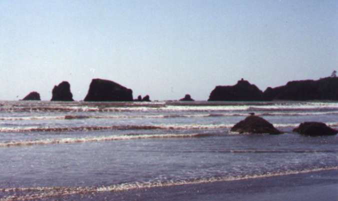 The Beaches: This refers to the ocean beaches north and south of Gray's Harbor, down Aberdeen and Hoquiam way. Home of the razor clam. Not to be confused with any of Seattle's local beaches. When I was a kid (I'm an Aberdeen boy, myself, having spent my grade school years and one year of junior high there), we always referred to the beaches running north from Ocean Shores to Moclips as "the North Beaches," while referring to those running south from Westport to Tokeland as "the South Beaches" (although I've recently seen them referred to, in at least one place, as "the North Beach" and "the South Beach," respectively. The North Beaches tend to be rockier with more driftwood, while the South Beaches tend to have more and bigger sand dunes and much less driftwood. One of the novel features of these beaches, unlike any of Oregon's beaches, for instance, is that you can drive on them--they are actually considered to be state highways. Recently, there has been a bill introduced in Olympia, however, that would prohibit all driving on Washington's beaches, but not without howls of protest from people living, working, and doing business in the communities that would be most directly impacted. My guess is that it won't be passed anytime soon. People aren't likely to take kindly to being foreclosed from flying kites out of car windows, for one thing. For more background, see Outrage Follows Move to Ban Beach Driving from the Associated Press.
Contrary to the working assumption of many a first-time Seattle tourist, Seattle is not on the Ocean. It's about a 125-mile drive if you want to get to a real ocean beach. Also, if you tried to drive on any of Seattle's beaches, you would probably be promptly arrested.
The Bluff: Magnolia Bluff. Most easily accessible through Discovery Park (the old Fort Lawton). Spectacular view of Puget Sound. Don't forget your binoculars. Also home to some of Seattle's worst mudslides.
Brain Dead Island: Bainbridge Island. I've been told that this was a term originally coined by local teens on Bainbridge Island (who obviously want off!). A closely related term, also coined by local teens it would seem, is "Brain Damage Island." I've been told that this term got started after a national magazine reported that Bainbridge High School had the nation's highest drug use by students. Regardless of the origin of either variant, certainly a good part of the staying power of either of these terms is Seattle's growing big city snobbishness that is liable to look at all who live across the water as undergoing a rather quaint form of devolution. The Brothers: A mountain in the Olympic Mountains, the one with the twin peaks, that can be seen against the western horizon. It was originally named, in 1857, by an early surveyor of Puget Sound, George Davidson of the U.S. Coast Survey. He named the mountain after the brothers of his fiancée, thus the name. Additionally, he also named Mt. Ellinor after his fiancée, Ellinor Fauntleroy and Mt. Constance after Ellinor's sister. All three, The Brothers, Mt. Ellinor, and Mt. Constance, are visible from Fauntleroy Cove, also named by Davidson. (Additionally, he named his boat after Ellinor's father.)
Central Washington: Actually a subsection of Eastern Washington, encompassing places as varied as Wenatchee, Yakima, the Tri-Cities, and Ellensburg (originally called Robber's Roost, but now home of Central Washington University), aligned roughly along the Columbia River as forming its backbone. See also The Basin.
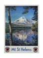
The Cascades: The Cascade Mountains, the mountain range you see when you look east over Lake Washington. Mount Rainier and Mount St. Helens are both part of the Cascade Mountain Range, but they are just two of the many mountains that form this range.
The Coast: Sometimes used by residents of eastern Washington (Eastsiders) to refer to western Washington. I suspect, however, that this is more normally an "inlander" term, and not just an Eastsider term, that refers to everthing west of the Cascades, encompassing not only Washington's coastal area, but Oregon's as well.
The Corridor: The I-5 Corridor, running from Bellingham in the north to Vancouver (WA) in the south, although some would extend it even further south, all the way to Eugene. At least 90 percent of the development and growth that has occurred in Washington state (and in Oregon, if we extend it further south) in the last 30 years has occurred in the Corridor (which for its entire length is seldom more than 30 miles wide).
The Cranberry Coast: Another term for the South Beaches area, running from Westport down to Tokeland, although you'll really only find cranberry bogs south of Grayland, I believe. When I was a kid down in Aberdeen back in the late '50s, we never used this term, so I suspect it is a more recent invention, undoubtedly intended to boost what has been a flagging cranberry industry recently.
The Dryside: Eastern Washington, a play off of Wetside, which is a play off of Westside (or Western Washington).
The Far Corner: The Pacific Northwest, generally taken as comprising the states of Washington, Oregon and Idaho, although in a narrower sense may be taken as comprising the state of Washington alone. Needless to say, Northwesterners are as likely to stress their psychic, as opposed to their mere geographic, distance from other locales.
The Gorge: The Columbia Gorge, a stretch of the river east of Portland that is noted for its constant strong winds. World-renowned windsurfer valhalla. The scenery's not bad either. Also can refer, I'm told, to the Gorge Amphitheater.
The Great Peninsula: The real name of the Kitsap Peninsula, originally according to the USGS. Kitsap, the name of the county, became attached to the peninsula after the fact, it would seem. Modern day "West Sounders" point to this in defence of the Kitsap Peninsula as not being a dependent peninsula of The Peninsula (Olympic, that is), but as being an independently attached (to the state) peninsula in its own right.
Green Lake: A popular lake, located north of Lake Union, just north of Woodland Park. The path around the lake has grown so popular, utilized by hoards of walkers, joggers, inline skaters, and bicyclists, they had to rebuild and widen it. With two life-guarded swimming beaches, and warmer water than other in-city swimming beaches, Green Lake is also a popular swimming hole, especially for youngsters, during the summer months, although some eschew swimming there because of the presence of a harmless parasite in the water, the source of the bane termed the Green Lake Itch. Mentioned by Oprah Winfrey on her show as the top "pick-up" place in Seattle. Pronounced as one word: "Greenlake." The Greenlake neighborhood, on the other hand, is all one word.
The Eastside: Geographically refers to Eastern Washington, or everything east of the Cascades. The term is also used more commonly to refer to the suburbs to the east of Seattle, on the "eastside" of Lake Washington--see the Streets & Beats section.
Harbor Island: Not a natural island, but in fact the largest man-made island in the United States, created from fill materials produced by the sluicing of Denny Hill (the Denny Regrade) and the Dearborn Cut. The land under Alaska Way and the Viaduct and the industrial area south of downtown (Sodo) were also created from the same fill materials.
The Inland Empire: This was orginally largely a railroader's term, I think, centered upon Spokane as being a major railroad hub dating way back. It might be thought of as encompassing all of eastern Washinton, eastern Oregon, and the southern portion of Idaho, although there are others, such as residents of "The Basin," who might dispute this, while still others, for quite opposite reasons, might wish to exclude the Okanogan.
Warning: Non-Nortwesterners should use these terms (in the vain hope of fitting in) only at the risk of being greeted by frequent blank stares. While some terms are known by virtually all Northwesterners, and actually spoken by many, others are known only to some or a few, while spoken by even fewer. However, if you hear one said, armed with this lexicon, you'll know what is meant.
The Island: Generally refers to Bainbridge Island, and not to Vashon Island, which is usually just called "Vashon".
Kitsap: The Kitsap Peninsula. Judging from several e-mail messages I've received, residents of the Kitsap Peninsula would seem to be adament in their conviction that their peninsula is not a peninsula of "The Peninsula" (the Olympic Peninsula), but is a free-standing peninsula in its own right independent of any other peninsula (one messenger even insisted that Kitsap is "The Peninsula"). Some of this is due, no doubt, to the growing prevalence of cross-sound ferry commuters who see themselves as being firmly connected economically to the Puget Sound basin community (megalopolis), while considering the Olympic Peninsula as an economic backwater primarily populated by unemployed loggers and fishermen, relegating "The Peninsula" to everything west of Hood Canal. They've even taken to calling themselves "West Sounders," as awkward as that may sound, and their geographic domain as "The West Sound," it would seem. Still, as ridiculous as this may seem from the perspective of an "East Sounder," one should not underestimate or too lightly cast aspersions on the depth of the pathos exhibited by the Kitsap resident on this issue, which they would seem to care about in earnest to the very depths of their souls. However, if the Kitsap Peninsula is not a peninsula of the Peninsula, geographically speaking anyway, it is not abundantly clear, to this writer at least, exactly where the appropriate boundary might be drawn that would make this distinction clear and indisputable, be it at the neck of land separating Hood Canal from Case Inlet, or alternatively along a line drawn just west of Highway 101, between the bend of the elbow formed by the southern tip of Hood Canal and the bend of the elbow formed by Hammersley Inlet and Oakland Bay (where Shelton is located). See also The West Sound and The Great Peninsula.
Kitsap County was originally named "Slaughter County" in 1857, named after a Lt. William Slaughter who'd been killed during the Native American uprising in Puget Sound. The name, however, was not very popular and some seven months later, the citizens of Slaughter County voted to change the name to Kitsap County, supposedly because "Kitsap" meant "good and brave" according to local tribal legend. It is unclear whether the voters were aware that it was also Chief Kitsap and his band who'd been responsible for the killing of Lt. Slaughter.
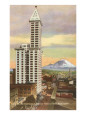
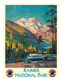
The Mountain: Mount Rainier. Such as in, "The Mountain is out." Every true Northwesterner knows immediately what that means (and where to look). The point being that most of the time, it ain't. But when it is, even life-long Northwesterners will gaze in some wonder, almost never failing to remark, "There's the Mountain."
The Ocean: The Pacific Ocean, not to be confused with the Sound.
The Okanogan: Northeastern Washington, A state of mind.
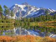
The Olympics: The Olympic Mountains, the mountain range you see when looking west across Puget Sound.
The Palouse: An area encompassing parts of southeastern Washington and Idaho, basically the the Palouse River basin. Pullman, home of the Cougs, is located in the Palouse. It is generally agreed that the Palouse gains its name from the Palouse River, which gained its name from the Palouse Indian tribe. There is less agreement, however, on the meaning and derivation of the term "palouse," with some theorizing that it comes from a local indian word, "palus," used to designate a village (specifically the main Palouse Indian village on the Palouse River), while others have theorized that it comes from a French word, "pelouse," meaning a prairie or grassy area, that fur trappers originally used to describe the area. The term "Palouse grass" actually designates a form of bunch grass. The famous Appaloosa breed of horses originates from the Palouse Indians, who originally bred them.
The Pass: Snoqualmie Pass, not to be confused with several other passes across the Cascades.
The Peninsula: The Olympic Peninsula. The Peninsula is still largely unspoiled, primarily due to the need to take a ferry to get to it--unless you want to drive down to Tacoma and across the Tacoma Narrows Bridge, or all the way down to Olympia. Proposals for cross-Sound bridges keep cropping up, however. The actual geographic extent of the Peninsula is a matter of some debate and controversy, due to the desire of the residents of the Kitsap Peninsula to secede from the Peninsula, declaring their peninsular independence, so to speak, in the form of the self-appellation, "The West Sound." They would seem to regard the Peninsula as composing everything west of Hood Canal, instead of everything west of Puget Sound. Having spent my childhood and early adolescence in Aberdeen, I can only say that Aberdonians considered the Peninsula to be everything north of Grays Harbor and Highway 12 (or the Chehalis River, if one wishes a more purely geographic marker), with "Southwest Washington" being everything south of there, a point of view that is quite consonant with the view of the typical Seattleite who with a certain casual disregard is in the habit of seeing everything west of the Sound as part and parcel of the Peninsula.
Poverty Rock: Mercer Island, a name dating back, I suspect, to pioneer days. Today, Mercer Island is hardly poor, however. I've heard that taxi drivers sometimes use the term in reference to a perceived paucity of tips emanating from the said locale (the rich tend to be penny pinchers), although I believe any connection here to the origination of this term is entirely apochryphal.
The Plateau: The Sammamish Plateau.
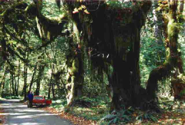 The Rain Forest: Refers to the forests on the west side of the Olympic Mountains, especially those in the Quinault, Queets, and Hoh River valleys. The Olympic's rain forest is a temperate rain forest the likes of which is to be found nowhere else. The Rain Forest, of course, is created by lots and lots of rain, in some places up to 200 inches a year. The result is as close to a fairy-tale land as nature can manage. Just don't forget your rain gear.
The Rock: My first thought was that "The Rock" was simply short for "Poverty Rock," referring to Mercer Island. Then someone e-mailed me that, no, Bainbridge Island is "The Rock." Next someone e-mailed me that, no, Vashon Island is "The Rock." Finally, someone e-mailed me that, no, Mercer Island is "The Rock." The one thing that they all have in common, of course, is that they're all islands. I do think that the use of "The Rock" for Mercer Island originates from "Poverty Rock," while its use for Bainbridge Island and Vashon Island undoubtedly is associated with Alcatraz ("The Rock"). I still think that the recent popularity of this term (especially on Bainbridge and Vashon) is a result of the popularity of the movie, The Rock (starring Nicholas Cage), among island teens--who obviously want off!
The Salish Sea: A term concocted by someone probably with too much time on their hands that refers to the combined waters of Puget Sound and the Georgia Strait, on the assumption that they are a common body of water divided only by a political boundary (despite Admiralty Inlet marking the entrance to Puget Sound, like a cork in a bottle). The term (Salish or Salishan) refers to the Coast Salish native peoples, who traditionally have lived in southwestern British Columbia and northwest Washington state, but claims that it came from those peoples are pure fantasy. The term was actually an endonym of the Flathead Nation (of the Inland Salish) and only applied later to other tribes who were linguistically related. The term will probably take hold only if Cascadia should become a unified political reality, something that, however, would require the dissolution of both the American and Canadian unions. Not likely to happen anytime soon, in other words.
The Skagit: The Skagit River. The Skagit River valley is best known for tulips and artists, both of which it has in abundance.
Sky River: The Skykomish River, which gave its foreshortened name to the first Sky River Rock Festival.
The Slough: The Sammamish Slough (a.k.a, the Sammamish River), not to be confused with Seattle Slew, the race horse. A reader mentioned that the Sammamish Slough is called a "slough" because of the sewage plant that was once at its head. In the dictionary, a "slough" is defined as a "backwater," among other things.
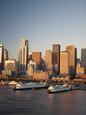
The Sound: Puget Sound, not to be confused with the Pacific Ocean (hint: the Ocean has breakers, the Sound doesn't).
The Strait: The Strait of Juan de Fuca (not to be confused with the Georgia Straits).
Vashon: Vashon Island.
The West Sound: A term coined originally by Ed Friedrich, a sports writer at The Bremerton Sun back in the mid-80s, to refer to the Kitsap Peninsula and environs. The actual extent of the region is somewhat amorphous, encompassing not just Kitsap, but Bainbridge, Quilcene, and even Port Townsend. The term, of course, whether this was its original intention or not, points to a desire among Kitsappians and others to more securely cement their affiliation with the remainder of the Puget Sound basin community ("The East Sound"?). Although this would seem to be illogical on purely geographic grounds (which would seem to clearly show, by any map that one might wish to procure, that the Kitsap Peninsula is a peninsula of the Olympic Peninsula (a peninsula of the Peninsula), it makes sense to some degree if we observe the socio-cultural gap that exists between the typical resident of Port Orchard and that of a town such as Shelton or McCleary. The "West Sound," in other words, has increasingly become a bedroom community of cross-sound white-collar commuters participating in the high-tech economic boom taking place along the I-5 corridor, while the Olympic Peninsula has largely remained ensconsed in an economy based upon rapidly diminishing natural resources (trees and fish) and high unemployment.
The Westside: Geographically, this refers to Western Washington, that is, everything west of the Cascades. The term is also used to refer to Seattle relative to the suburbs east of Lake Washington, or the Eastside.
The Wetside: A humorous take-off on "The Westside," derived from the fact that the Westside can get rather soggy, while the Eastside is known to be a bit dry. See also The Dryside.
The Wet Coast: A play on "West Coast", in this case referring to the Wetside's Pacific edge, from Ilwaco to Cape Flattery, which, on the wrong side of the Olympic Mountains, gets two to five times the rainfall Seattle gets.
We're dedicated to helping you find the exact poster or print you're looking for! If you can't find it here, and I'll see if I can hunt it down for you!
Contact:Bookmark this Site!
(IE or Firefox)